
Bhubaneswar: The Deep Depression over the East-central Bay of Bengal has intensified into a Cyclonic Storm named “Remal,” the India Meteorological Department (IMD) announced in its latest bulletin.
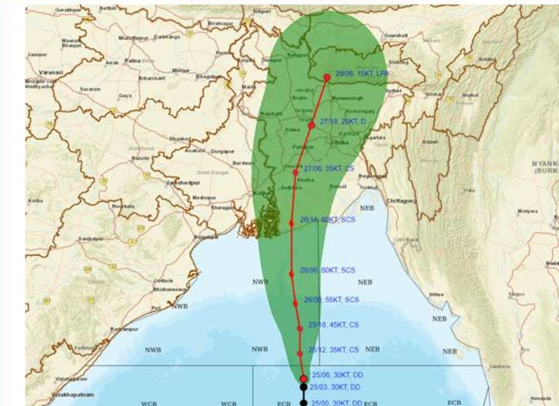
The system, moving northward at a speed of 12 kmph, was officially classified as Cyclonic Storm “Remal” (pronounced as “Re-Mal”) as of 1730 hrs IST on May 25, 2024. The storm is centered over the North and adjoining East-central Bay of Bengal near latitude 18.8°N and longitude 89.5°E. It is located approximately 360 km south-southeast of Khepupara (Bangladesh), 350 km south-southeast of Sagar Islands (West Bengal), and 390 km south-southeast of Canning (West Bengal).
The IMD forecasts that Cyclonic Storm “Remal” will continue to move northwards, intensifying into a Severe Cyclonic Storm by the morning of May 26. The storm is expected to cross the coasts of Bangladesh and adjoining West Bengal between Sagar Island and Khepupara by midnight on May 26, with wind speeds reaching 110-120 kmph, gusting up to 135 kmph.
Heavy Rainfall Warning
West Bengal:
May 26-27: Light to moderate rainfall at most places, with heavy to very heavy rainfall at a few places over coastal districts and eastern districts of Gangetic West Bengal adjacent to Bangladesh. Isolated extremely heavy rainfall (≥ 20 cm) is expected.
May 27-28: Light to moderate rainfall at most places, with heavy to very heavy rainfall at isolated places over eastern districts of Sub-Himalayan West Bengal.
Odisha:
May 25-26: Light to moderate rainfall at most places, with isolated heavy rainfall over North Coastal Odisha.
Wind Warning
Bay of Bengal:
Gale wind speeds of 60-70 kmph, gusting to 80 kmph, will prevail over the central Bay of Bengal until the morning of May 26, decreasing thereafter.
North Bay of Bengal: Wind speeds will increase to 95-105 kmph, gusting to 115 kmph, early on May 26, and 110-120 kmph, gusting to 135 kmph, by noon until midnight. Speeds will then decrease, reaching 70-80 kmph, gusting to 90 kmph, by the morning of May 27.
Bangladesh and West Bengal Coasts:
Squally winds of 40-50 kmph, gusting to 60 kmph, will prevail along and off these coasts from tonight.
Wind speeds will increase to 60-70 kmph, gusting to 80 kmph, by the morning of May 26, and 100-120 kmph, gusting to 135 kmph, by the evening, lasting until early morning on May 27. Winds will then decrease to 60-70 kmph, gusting to 80 kmph, by the afternoon, and 50-60 kmph, gusting to 70 kmph, by the night of May 27.
Howrah, Hoogly, Kolkata, and East Medinipur Districts:
Squally winds of 40-50 kmph, gusting to 60 kmph, will commence on the evening of May 26. Winds will increase to 70-80 kmph, gusting to 90 kmph, during the night, except in East Medinipur, where speeds may reach up to 60-70 kmph, gusting to 80 kmph.
Odisha Coasts:
Squally winds of 40-50 kmph, gusting to 60 kmph, will prevail until the morning of May 27.
The IMD advises residents in the affected areas to stay updated with the latest weather information and take necessary precautions to ensure safety during the severe weather conditions expected over the next few days.