
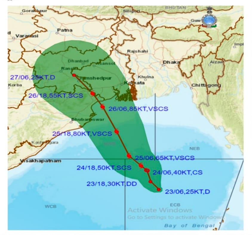
Bhubaneswar: Indian Meteorological Department (IMD) informed that the cyclonic storm brewing at Bay of Bengal is likely to make a landfall somewhere between Paradip and Sagar Island on May 26 evening.
According to the preliminary forecast track, the cyclone is likely to cross Balasore coast near Chandipur.
A low pressure area formed over the east-central Bay of Bengal on May 22 intensified into a depression on May 23. According to IMD the depression is very likely to move north-northwestwards and intensify into a cyclonic storm by May 24 and further into a very severe cyclonic storm in the subsequent 24 hours.”
Mrutyunjay Mohapatra, IMD Director General said, “The cyclone will cross Odisha and West Bengal coasts on 26 evening with wind speed ranging from 155 -165 kmph gusting to 185 kmph”
Meanwhile, the Regional Meteorological Centre has issued a Red Warning for heavy to very heavy rainfall in eight districts of Odisha in view of the forecasted Cyclone Yaas.
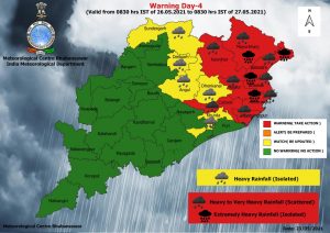
Heavy to very heavy rainfall very likely to occur at a few places over the districts of Balasore, Bhadrak, Jajpur, Kendrapara, Cuttack, Jagatsinghpur, Mayurbhanj, Keonjhar with extremely heavy rainfall at one or two places over the districts of Balasore, Bhadrak, Kendrapara and Mayurbhanj from May 26-27.
While yellow warning has been issued for five districts. Heavy rainfall likely to occur at one or two places over the districts of Sundargarh, Deogarh, Angul, Dhenkanal and Khurda on May 26-27.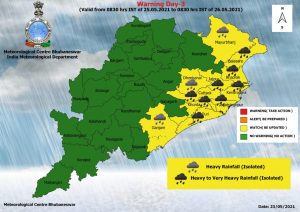
Similarly, heavy to very heavy rainfall likely to occur at one or two places over the districts of Balasore, Bhadrak, Jajpur, Kendrapara, Cuttack, Jagatsinghpur, Khurda, Puri and heavy rainfall at one or two places over the districts of Mayurbhanj, Dhenkanal and Ganjam on May 25-26.