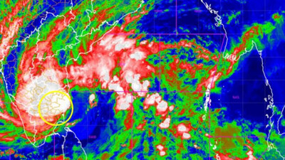
Bhubaneswar: A fresh weather system is brewing in the north Bay of Bengal, with the India Meteorological Department (IMD) predicting the formation of a cyclonic circulation in the next 24 hours. The system, identified as the remnant of Tropical Cyclone Wipha, is likely to intensify into a low-pressure area within the following 48 hours.
IMD scientist Umasankar Das shared the development via his official handle on X (formerly Twitter), stating: “A cyclonic circulation (Remnant of Tropical Cyclone #Wipha) is likely to emerge over north #BayofBengal during next #24hours. Under its influence, a #LowPressure area is likely to form over the same region in the subsequent #48hours.”
Possible Weather Changes Ahead
The potential low-pressure system is expected to alter the current weather dynamics over the Bay of Bengal and influence conditions in eastern coastal states. Meteorologists suggest that such formations during the monsoon period could bring widespread rainfall, thunderstorms, and gusty winds.
Coastal Regions on Alert
Authorities have advised residents, particularly those in Odisha and West Bengal, to stay updated with official weather bulletins. Fishermen are likely to be barred from venturing into the sea as the system progresses, considering the risk of turbulent sea conditions and strong winds.
Monitoring and Preparedness
The IMD continues to monitor the evolving weather pattern and will issue updated forecasts and warnings as necessary. Local administrations in vulnerable areas are expected to remain on alert and initiate precautionary measures if the system intensifies further.
As monsoon systems often interact with remnants of previous cyclones, such developments are not unusual for this time of the year. However, any intensification will be closely watched given the potential for localized flooding and disruptions.


