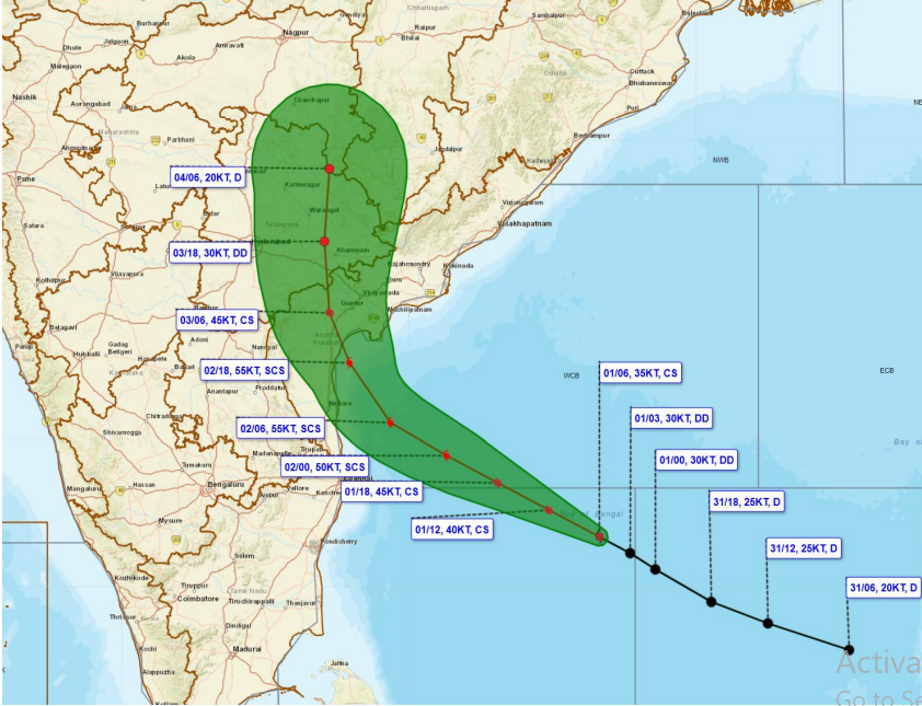
Bhubaneswar: With Cyclonic Storm ‘Murasu’ gaining strength over the Bay of Bengal, the IMD has forecast its intensification into a Severe Cyclonic Storm by the early hours of November 2. The system is likely to make landfall along the south Andhra Pradesh coast between late Monday night and early Tuesday, with wind speeds reaching 100-110 kmph and gusts of up to 120 kmph.
The storm was centred over the southwest and adjoining westcentral Bay of Bengal at 5.30 pm on Sunday, after moving west-northwestwards at a speed of 25 kmph during the preceding six hours, the India Meteorological Department (IMD) said in its latest bulletin.
Located near latitude 12.7°N and longitude 84.1°E, the system was approximately 420 km east-southeast of Chennai, 490 km east-southeast of Nellore and 500 km southeast of Machilipatnam. It was also positioned around 510 km east-southeast of Kavali, 530 km southeast of Ongole and 560 km south-southeast of Visakhapatnam.
The weather agency said Murasu is very likely to maintain its west-northwestward movement and intensify further into a Severe Cyclonic Storm over the westcentral Bay of Bengal by the early hours of Monday.
It is then expected to move northwestwards and cross the south Andhra Pradesh coast between Nellore and Narsapur, close to Ongole. The likely landfall window is between 11.30 pm on November 2 and 4 am on November 3.
At the time of crossing the coast, the storm is likely to pack maximum sustained wind speeds of 100-110 kmph, with gusts reaching up to 120 kmph.
The IMD is monitoring the system’s movement and intensity, with further updates on its forecast track and likely impact expected in subsequent bulletins.