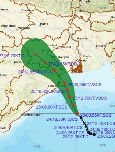
Bhubaneswar: Indian Meteorological Department (IMD) on Tuesday forecasted that the landfall of Cyclone Yaas could occur between Dhamra and Chandbali port on May 26.
The IMD bulletin read, “It is very likely to move north-northwestwards, intensifying further into a Very Severe Cyclonic Storm during next 12 hours. It would continue to move north-northwestwards, intensify further and reach Northwest Bay of Bengal near north Odisha coast very close to Chandbali-Dhamra port by the early morning of Wednesday, May 26. It is very likely to cross north Odisha-West Bengal coasts between Paradip and Sagar Island close to north of Dhamra and south of Balasore, during noon of Wednesday, the 26th May as a Very Severe Cyclonic Storm.”

The wind speed at the time of landfall would be 155 – 165 kmph gusting up to 185 kmph. “The wind speed 155-165 kmph gusting to 185 kmph over northwest Bay of Bengal and along & off north Odisha and adjoining West Bengal coasts including Jagatsinghpur, Kendrapara, Bhadrak, from early morning of May 26 and will extend to Balasore district of Odisha from the forenoon May 26, 120-130 kmph gusting to 145 kmph over Mayurbhanj district of Odisha from early morning of May 26. Gale wind speed reaching 80-90 kmph gusting to 100 kmph would prevail over Puri, Cuttack, Khurda, Jajpur and Nayagarh districts of Odisha during the same period,” IMD said.
Meanwhile, Chief Minister Naveen Patnaik has directed the Minister of State for Home, Dibyashankar Mishra, to camp at Balasore to monitor the situation.