
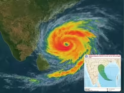
Bhubaneswar: The India Meteorological Department (IMD) on Tuesday issued a midday alert, warning that Severe Cyclonic Storm ‘Montha’ (pronounced Mon-Tha) is inching closer to the Andhra Pradesh coast and will likely make landfall near Kakinada late this evening or night. The system is expected to unleash heavy rain, strong winds, and rough sea conditions across several parts of southern Odisha.
According to the IMD’s Meteorological Centre in Bhubaneswar, the cyclone was centered at 8:30 a.m. IST near latitude 14.9°N and longitude 82.9°E, around 160 km south-southeast of Machilipatnam, 240 km from Kakinada, and 530 km south-southwest of Gopalpur. Moving north-northwest at 12 kmph, the storm is likely to make landfall between Machilipatnam and Kalingapatnam, with wind speeds of 90–100 kmph, gusting up to 110 kmph.
Early impacts of the cyclone have already been felt in parts of Odisha. A squall with wind speeds reaching 60 kmph swept across Gopalpur around 2:40 a.m., while Ganjam and Gajapati districts witnessed heavy rainfall. The IMD recorded 12 cm of rain in Patrapur (Ganjam), 11 cm in Gosani (Gajapati), and up to 9 cm in several areas including Sankhemundi, Paralakhemundi, and Kukudahandi. Berhampur received 7 cm, and Pottangi (Koraput) as well as Bangiriposi (Mayurbhanj) recorded 4 cm each.
The weather office also noted a sharp dip in temperatures, with South Odisha recording a fall of nearly 5°C and other regions witnessing a 2–3°C drop. Paradip recorded the highest temperature at 35.2°C, while Phulbani and Angul registered the lowest minimum of 19°C.
Forecast and Warnings Across Odisha
The IMD has placed several districts under red, orange, and yellow warnings until November 4, cautioning residents about intense rainfall, gusty winds, and lightning activity.
Red Warning (Oct 28–29): Extremely heavy rainfall is expected in Malkangiri, Koraput, Rayagada, Gajapati, and Ganjam with wind speeds of 60–80 kmph.
Orange Warning: Heavy to very heavy rainfall (7–20 cm) in Nabarangpur, Kalahandi, Kandhamal, Nayagarh, Khordha, and Puri.
Yellow Warning: Moderate rain and wind (40–60 kmph) likely across Cuttack, Dhenkanal, Angul, Jagatsinghpur, Kendrapada, Balasore, and Mayurbhanj.
On October 29–30, the system will continue to bring heavy rainfall to southern and western Odisha, gradually weakening thereafter. Thunderstorms with gusty winds (30–40 kmph) may persist in Jharsuguda, Sambalpur, Deogarh, Keonjhar, and Mayurbhanj through the weekend.
Sea and Fishermen Advisory
The IMD reported gale winds of 90–100 kmph gusting to 110 kmph over the southwest and west-central Bay of Bengal, creating high to very high sea conditions. Along and off the Odisha coast, winds are expected to strengthen to 70–80 kmph before easing after landfall. Fishermen have been strictly advised not to venture into the sea until October 30, and those already at sea have been urged to return immediately.
Public Advisory
Authorities have advised residents in vulnerable areas to remain vigilant and follow official updates. The IMD has recommended downloading the MAUSAM, Meghdoot, and Damini mobile apps for localized forecasts, lightning alerts, and agromet advisories. Regular updates are available on @mcbbsr (X) and the MC Bhubaneswar Facebook page.