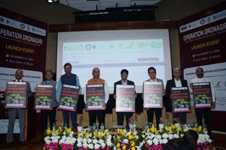
New Delhi: In a move to revolutionize India’s use of geospatial technology, Professor Abhay Karandikar, Secretary of the Department of Science and Technology (DST), launched Operation Dronagiri at the Foundation for Innovation and Technology Transfer (FITT) at IIT Delhi. This pilot project, under the National Geospatial Policy 2022, is designed to demonstrate how geospatial technologies can improve the quality of life and boost ease of doing business across India.
In his keynote address, Professor Karandikar highlighted that Operation Dronagiri is one of DST’s major initiatives to liberalize and utilize geospatial data through enhanced infrastructure, skills, and standardized applications. “In the first phase, we will implement the project in Uttar Pradesh, Haryana, Assam, Andhra Pradesh, and Maharashtra. The pilot will focus on integrating geospatial data across three sectors—agriculture, livelihoods, and logistics and transport. This will set the foundation for a nationwide rollout,” he stated.
A key highlight of the launch was the unveiling of the Integrated Geospatial Data Sharing Interface (GDI), a platform that supports seamless data sharing and access for applications such as urban planning, environmental monitoring, and disaster management. GDI allows organizations to leverage spatial data for public benefit, transforming geospatial data into actionable insights, similar to how the Unified Payments Interface (UPI) enabled financial inclusion.
The GDI platform is equipped with tools for data processing, analysis, and efficient sharing, enabling stakeholders to make data-driven decisions. This collaborative approach is expected to lead to faster, more coordinated responses for infrastructure monitoring, disaster relief, and environmental protection.
Professor Karandikar expressed that the full implementation of Operation Dronagiri will adopt a Public-Private Partnership (PPP) model, akin to UPI’s deployment, and called on industry and private sector players to be actively involved. “The PPP model will be pivotal for a successful nationwide rollout, driving industry engagement in the geospatial sector’s transformation,” he said.
Dr. Srikant Sastri, Chairman of the Geospatial Data Promotion and Development Committee, called Operation Dronagiri a key step in positioning India as a global leader in geospatial technology. “Our goal is to turn data into impactful solutions with direct socioeconomic benefits. The involvement of private sector and startups will be essential to make geospatial data accessible and impactful,” he remarked.
To support startups, a Grand Challenge was announced to select and support startups in developing Proofs of Concept (POCs) that tackle real-world challenges within Operation Dronagiri’s designated sectors. Startups chosen through the initiative will gain mentorship, resources, and access to geospatial datasets, creating a dynamic platform for early-stage and growth-stage startups.
The project will be overseen by the IIT Tirupati Navavishkar I-Hub Foundation (IITTNiF), with operational support from Geospatial Innovation Accelerators (GIAs) based at IIT Kanpur, IIT Bombay, IIM Calcutta, and IIT Ropar. The Geospatial Innovation Cell, a part of DST, will drive the project’s implementation.
Hitesh Kumar S. Makwana, Surveyor General of India, praised DST’s efforts to implement the National Geospatial Policy 2022, while Professor K N Satyanarayana, Director of IIT Tirupati, highlighted the critical role of Technology Innovation Hubs in accelerating geospatial advancements.
By promoting geospatial innovation, Operation Dronagiri aims to create an ecosystem where cutting-edge geospatial technologies and data sharing can positively impact citizens’ lives and support various industries. This landmark project is set to showcase India’s potential as a global leader in the geospatial sector.

