
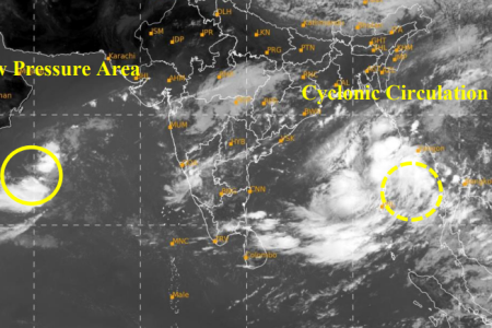

Bhubaneswar: A cyclonic circulation over the central Andaman Sea, which persisted through today, is set to intensify into a low-pressure area within the next 24 hours, according to the India Meteorological Department (IMD). The system is expected to strengthen into a depression by the morning of 22nd October and further intensify into a cyclonic storm by 23rd October, 2024.
IMD reported that the cyclonic circulation was located over the North Andaman Sea in the early hours today (0530 IST) and continued over the region into the forenoon (0830 IST). The department, via a statement on its platform ‘X’, informed: “A Low-Pressure Area is very likely to form over the Eastcentral Bay of Bengal and adjoining North Andaman Sea during the next 24 hours.”
The developing system is forecasted to move west-northwestwards and could potentially reach the northwest Bay of Bengal, near the Odisha-West Bengal coasts, by the morning of 24th October. The storm has been named ‘Dana,’ a designation proposed by Qatar.
Rainfall and Wind Warnings
Under the influence of the impending cyclone, the IMD has predicted that rainfall will begin on 23rd October, with intensity increasing on 24th and 25th October. Coastal Odisha and West Bengal are expected to experience heavy to extremely heavy rainfall during this period.
The IMD also warned that wind speeds could escalate to 100-120 km/h at sea during the landfall of the storm.
Authorities are urging residents in vulnerable areas to stay informed about further developments and to follow safety protocols as the cyclone approaches.